GeoSetter is a program to display and edit the Geodata along with other metadata of your images with photo files. It’s free to download and access the new utility for PC Windows 7/8/10!
GeoSetter PC
It is a tool that allows the user to modify the data of your photo files, the geographic position data, and more. Other metadata such as IPTC, XMP, or EXIF on digital photos.
With the assistance of Google Maps, you can decide the spot of all your image.
It’s freeware for Windows, requires Internet Explorer 10 or above. Keep in mind that its embedded map does not work on Windows XP!
The present version is 3.5.5, available on 29 October 2018.
Main features
These highlights contribute to building up GeoSetter.
Support various formats and so on
It’s feasible to read and write formats including JPEG and TIFF. Additionally, it assists camera RAW formats like DNG, CRW, CR2, THM, NEF, NRM, MRW, PEF, ORF, ARW, etc.
ExifTool
Choose and deploy that gear by Phil Harvey for writing data.
IPTC data
It’s completely editable.
Localizable user interface
It’s simple to delve deeper into the content in English, German, French, Czech, Italian, Swedish, Danish, Dutch, Spanish, or Russian. Besides, it’s obtainable in Japanese, Chinese, and Norwegian languages as well.
Change
It’s easy to make the taken date different.
Show
The current geo-coordinates, directions, and tracks on embedded Google Maps map. That needs an Internet connection.
Set
Geodata by controlling embedded Google Maps map or by entering known values for coordinates with altitude.
Automatically fill
The location IPTC fields and altitude values
Synchronize
The process with track files will occur (NMEA, PLT, GPX, IGC, Sony LOG…)
Synchronization will happen to already geotagged photos with buddy ones/
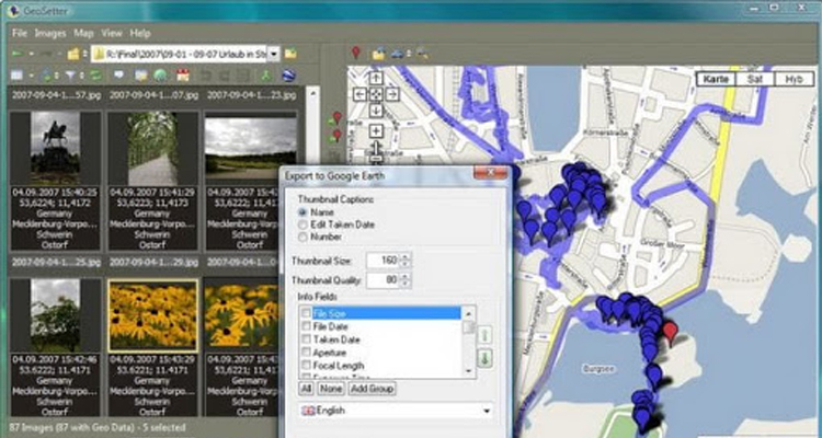
Google Earth export
Join and learn how to export whatever you want
GeoSetter is a free application for PC Windows to download. It’s great to teach, learn, and study geography.